Friday, April 10, 2020
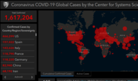
SoCal GIS Software Giant Powers Johns Hopkins COVID-19 Map
 One of the most powerful tools in tracking what's going on with the worldwide, COVID-19 pandemic, has been the Johns Hopkins University COVID-19 Map, which it turns out, was developed by a Southern California software company--Redlands-based Esri. According to a story about how the Johns Hopkins map was created, a small team at Johns Hopkins created the map based on work they had already been doing for spotting likely measles hotspots based on ArcGIS. According to the report, that experiement made it straightforward to build a similar dashboard for COVID-19. Esri now has been helping the Johns Hopkins team with their efforts, and in particular, with scaling out for the demand being placed to access that data, according to the report.